


このアプリのYoutube動画がある場合はURLを送信してください。詳細 »
APPLICATION INFO - iPhoneアプリの詳細情報
Norgeskart Outdoors has all what you need for hiking, biking, boating or skiing. Everything can be made available for offline use without mobile coverage.
The app was first launched in 2010 under the name Norgeskart, but changed its name to Norgeskart Outdoors in 2018. It is among the most popular hiking and map apps in Norway. Much has happened since it was first launched and there is still a lot to come!
Plan your next trip by downloading tours and descriptions directly in the app from TellTur and GodTur. Everything available regardless of mobile coverage. For Telltur you can register with the app when you arrive at a destination and compete with others to visit most places. You can easily find current trips by filtering and sorting the list of hiking destinations from your location or center of the screen.
Register points of interest (POIs), routes and record GPS tracks. These can, if desired, be written to GPX files or uploaded to norgeskart.avinet.no. You can then look at your own data in the browser and easily transfer between phones and tablets. In the app you can also read content from GPX files that you find on ut.no or from other sources.
This app contains both free and paid content (see complete overview below). By paying for a subscription, you support the further development of the app and take full advantage of all the exciting things we have to offer.
Free content:
------------------
- Topographical and nautical maps for Norway
- View place name and heigh/depth for cursor position
- Search for place names, addresses or coordinates
- Property borders and UTM grid layers
- Directions to POIs and addresses
- Import and export of GPX files
- GPS track recording
- Diagrams and details for tracks
- Create own routes and POIs
- Compass
Premium subscription (59 NOK a year):
------------------
- Download maps for offline use
- Trip suggestions from godtur.no and telltur.no
- Check in TellTur trips upon arrival at destination (is now free until 1. April 2021)
- Access to map portal norgeskart.avinet.no
- Upload POIs, tracks and routes
- Synchronize your data across devices
- Economic (N5 raster) map
- Historical map
- Mountain bike routes
- Pistes for Alpine and Cross-country
- Avalanche awareness and steepness
- Weak ice
- Snow depth and skiing conditions
- Snowmobile tracks
- Sea depths and lake depths
- Outports. Not nationwide.
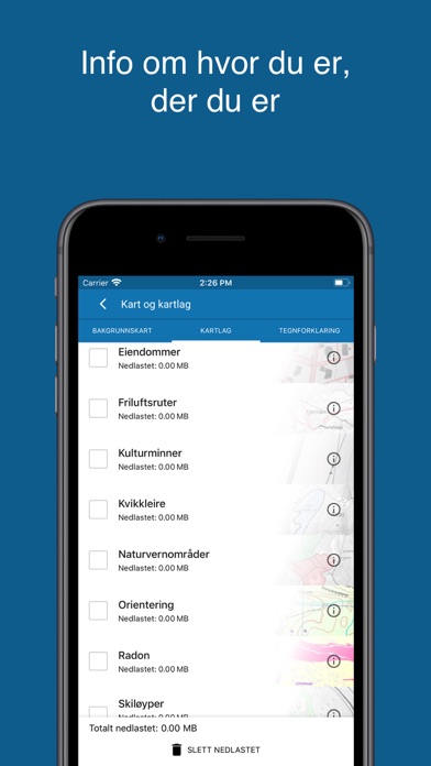
- Conservation areas
- Clay and radon
- Open air routes summer and winter
- Activities (bath spots, campfires etc). Not nationwide.
- Facilities (toilets, parkings etc). Not nationwide.
The following applies to the auto-renewable subscriptions:
- Payment will be charged to iTunes Account at confirmation of purchase
- Subscription automatically renews unless auto-renew is turned off at least 24-hours before the end of the current period
- Account will be charged for renewal within 24-hours prior to the end of the current period, and identify the cost of the renewal
- Subscriptions may be managed by the user and auto-renewal may be turned off by going to the user's Account Settings after purchase
- Any unused portion of a free trial period, if offered, will be forfeited when the user purchases a subscription to that publication, where applicable
Terms of use: https://norgeskart.wiki/en/terms-of-use-norgeskart-outdoors/
Privacy policy: https://norgeskart.wiki/en/privacy-policy-norgeskart-outdoors/
The app was first launched in 2010 under the name Norgeskart, but changed its name to Norgeskart Outdoors in 2018. It is among the most popular hiking and map apps in Norway. Much has happened since it was first launched and there is still a lot to come!
Plan your next trip by downloading tours and descriptions directly in the app from TellTur and GodTur. Everything available regardless of mobile coverage. For Telltur you can register with the app when you arrive at a destination and compete with others to visit most places. You can easily find current trips by filtering and sorting the list of hiking destinations from your location or center of the screen.
Register points of interest (POIs), routes and record GPS tracks. These can, if desired, be written to GPX files or uploaded to norgeskart.avinet.no. You can then look at your own data in the browser and easily transfer between phones and tablets. In the app you can also read content from GPX files that you find on ut.no or from other sources.
This app contains both free and paid content (see complete overview below). By paying for a subscription, you support the further development of the app and take full advantage of all the exciting things we have to offer.
Free content:
------------------
- Topographical and nautical maps for Norway
- View place name and heigh/depth for cursor position
- Search for place names, addresses or coordinates
- Property borders and UTM grid layers
- Directions to POIs and addresses
- Import and export of GPX files
- GPS track recording
- Diagrams and details for tracks
- Create own routes and POIs
- Compass
Premium subscription (59 NOK a year):
------------------
- Download maps for offline use
- Trip suggestions from godtur.no and telltur.no
- Check in TellTur trips upon arrival at destination (is now free until 1. April 2021)
- Access to map portal norgeskart.avinet.no
- Upload POIs, tracks and routes
- Synchronize your data across devices
- Economic (N5 raster) map
- Historical map
- Mountain bike routes
- Pistes for Alpine and Cross-country
- Avalanche awareness and steepness
- Weak ice
- Snow depth and skiing conditions
- Snowmobile tracks
- Sea depths and lake depths
- Outports. Not nationwide.
- Conservation areas
- Clay and radon
- Open air routes summer and winter
- Activities (bath spots, campfires etc). Not nationwide.
- Facilities (toilets, parkings etc). Not nationwide.
The following applies to the auto-renewable subscriptions:
- Payment will be charged to iTunes Account at confirmation of purchase
- Subscription automatically renews unless auto-renew is turned off at least 24-hours before the end of the current period
- Account will be charged for renewal within 24-hours prior to the end of the current period, and identify the cost of the renewal
- Subscriptions may be managed by the user and auto-renewal may be turned off by going to the user's Account Settings after purchase
- Any unused portion of a free trial period, if offered, will be forfeited when the user purchases a subscription to that publication, where applicable
Terms of use: https://norgeskart.wiki/en/terms-of-use-norgeskart-outdoors/
Privacy policy: https://norgeskart.wiki/en/privacy-policy-norgeskart-outdoors/
 このアプリはiPhone、iPadの両方に対応しています。
カテゴリー
ナビゲーション
ナビゲーション
リリース
2018/7/31
2018/7/31
更新
2021/5/15
2021/5/15
バージョン
1.3.8
1.3.8
言語
サイズ
24 MB
24 MB
条件
このバージョンの新機能
- Added map layer Access restrictions (nature)
- Added filter by name for TellTur
- Improved handling of poor mobile network when checking in TellTur
- Improved download of TellTur family members
- Improved download speed of TellTur trips by reducing numb
- Added map layer Access restrictions (nature)
- Added filter by name for TellTur
- Improved handling of poor mobile network when checking in TellTur
- Improved download of TellTur family members
- Improved download speed of TellTur trips by reducing numb
スクリーンショット - iPhone | iPad
スクリーンショット - iPhone | iPad
» 目的別iPhoneアプリ検索
- 辞書 » 日本語対応の辞書 » 英和辞典
- 学習 » 英単語 » 英会話 » クイズで楽しく
- スケジュール » 管理 » Googleカレンダー


Yahoo!乗換案内
Yahoo Japan Corp.無料
Google マップ - ナビ、乗換案内
Google LLC無料
Yahoo!カーナビ
Yahoo Japan Corp.無料
乗換NAVITIME(乗換ナビタイム) - 運行情報や路線図..
NAVITIME JAPAN CO.,LTD.無料
Yahoo! MAP-ヤフーマップ
Yahoo Japan Corp.無料
乗換案内
Jorudan Co.,Ltd.無料
賃貸物件検索 SUUMO(スーモ)でお部屋探し
Recruit Co.,Ltd.無料
NAVITIME(乗換と地図の総合ナビ)
NAVITIME JAPAN CO.,LTD.無料
NAVITIMEドライブサポーター - カーナビ&渋滞情報&..
NAVITIME JAPAN CO.,LTD.無料
お部屋探しはライフルホームズ賃貸・マンション・不動産物件検索
LIFULL Co., Ltd無料


CatchApp新着アプリレビュー
 日本縦断てつどうの旅」")
様々な楽しみ方で運転士として成長していく鉄道運転士育成RPG「プラチナ・トレイン(プラトレ) 日本縦断てつどうの旅」
2016-05-17 00:00

日本語にはない英語発音のリスニングを楽しく学べる「発音どっち?英語リスニング 」
2014-12-20 12:00

指先の瞬発力が試されるカジュアルゲーム「早撃ちパニック」をリリース!
2014-12-08 15:21
新着アプリ動画
-
 ¥1500
¥1500
-
 ¥600
¥600
-
 ¥3000
¥3000