


このアプリのYoutube動画がある場合はURLを送信してください。詳細 »
APPLICATION INFO - iPhoneアプリの詳細情報
The Border Route Trail in the Boundary Waters Canoe Area is one of the most remote and rugged backpacking trails that Minnesota has to offer! Straddling the Canadian Border, this 65-mile trail offers spectacular views and pristine wilderness for those tough enough to handle it!
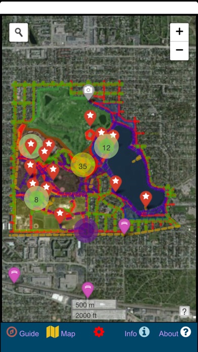
This app was created to assist wanderers in their journey along the BRT. It is loaded with useful trail information including the route of the BRT, portages, spur trails, campsites, vistas, water sources, parking areas, boundaries, evacuation points, and much more! Each data point and trail line is interactive, providing more information when upon tapping. The icons are informative and color-coded for immediate recognition, and layers that are not being used can be turned off to simplify the map presentation.
Offline imagery and topographic maps are bundled along with this app so that there is no need for an internet connection after installation. This is important, as the BRT is so remote that any kind of cell phone reception is highly unlikely. The app has the option to utilize GPS to follow your position on the map. This too is very essential, as many parts of the BRT are overgrown, crossed by other trails, and poorly marked. Having the confidence that you are staying on the trail is a blessing when you wish to avoid needing to backtrack.
In addition to a map view presentation, there is also a cross-sectional view of the BRT that can be expanded so that you can easily see where the ridges and valleys are. Highlight a portion of the cross-section and you can zoom in to that specific part of the trail. Much quicker and easier than trying to read topography from a map!
For those who prefer a more traditional information delivery style, there are a series of sections dedicated to describing the trail conditions, campsites, and other info through writing. This information is always changing, so be sure to check for the most recent updates at the official Border Route Trail Association website!
This app was designed for the BRT and tested on the trail. It has already proven to be invaluable for anyone considering hiking sections or the entirety of the trial. Although the Border Route Trail may be shorter and lesser-known than some other trails, it has a purity and ruggedness that set it apart from the rest. There is truly no better way to experience the Boundary Waters Canoe Area than on foot!
 このアプリはiPhone、iPadの両方に対応しています。
カテゴリー
ナビゲーション
ナビゲーション
リリース
2020/3/26
2020/3/26
更新
2021/1/20
2021/1/20
バージョン
1.0.3
1.0.3
言語
サイズ
141.7 MB
141.7 MB
条件
このバージョンの新機能
Minor bug fix! No new trail updates from 2020 due to COVID-19.
Minor bug fix! No new trail updates from 2020 due to COVID-19.
スクリーンショット - iPhone | iPad
スクリーンショット - iPhone | iPad
GeoPOI LLC の他のアプリ » もっと見る
» 目的別iPhoneアプリ検索
- 辞書 » 日本語対応の辞書 » 英和辞典
- 学習 » 英単語 » 英会話 » クイズで楽しく
- スケジュール » 管理 » Googleカレンダー


Yahoo!乗換案内
Yahoo Japan Corp.無料
Google マップ - ナビ、乗換案内
Google LLC無料
Yahoo!カーナビ
Yahoo Japan Corp.無料
乗換NAVITIME(乗換ナビタイム) - 運行情報や路線図..
NAVITIME JAPAN CO.,LTD.無料
Yahoo! MAP-ヤフーマップ
Yahoo Japan Corp.無料
乗換案内
Jorudan Co.,Ltd.無料
賃貸物件検索 SUUMO(スーモ)でお部屋探し
Recruit Co.,Ltd.無料
NAVITIME(乗換と地図の総合ナビ)
NAVITIME JAPAN CO.,LTD.無料
NAVITIMEドライブサポーター - カーナビ&渋滞情報&..
NAVITIME JAPAN CO.,LTD.無料
お部屋探しはライフルホームズ賃貸・マンション・不動産物件検索
LIFULL Co., Ltd無料


CatchApp新着アプリレビュー
 日本縦断てつどうの旅」")
様々な楽しみ方で運転士として成長していく鉄道運転士育成RPG「プラチナ・トレイン(プラトレ) 日本縦断てつどうの旅」
2016-05-17 00:00

日本語にはない英語発音のリスニングを楽しく学べる「発音どっち?英語リスニング 」
2014-12-20 12:00

指先の瞬発力が試されるカジュアルゲーム「早撃ちパニック」をリリース!
2014-12-08 15:21
新着アプリ動画
-
 ¥1500
¥1500
-
 ¥600
¥600
-
 ¥3000
¥3000