


このアプリのYoutube動画がある場合はURLを送信してください。詳細 »
APPLICATION INFO - iPhoneアプリの詳細情報
“MapOut saves the day by using a simple interface to draw routes, and check out elevation profiles… I’m pretty blown away by its capabilities.” – Alee from cyclingabout.com
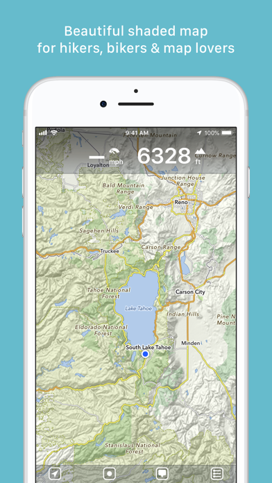
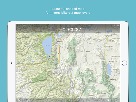
Offline map covering the whole world for iPhone and iPad. Almost as beautiful as a paper map - only more versatile.
- For hikers: With an easy-to-read representation of the terrain, even in the furthest corners without internet
- For cyclists: With cycling route network, speed and distance display
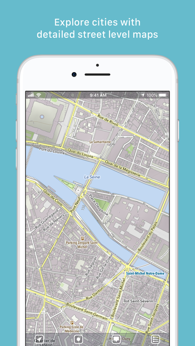
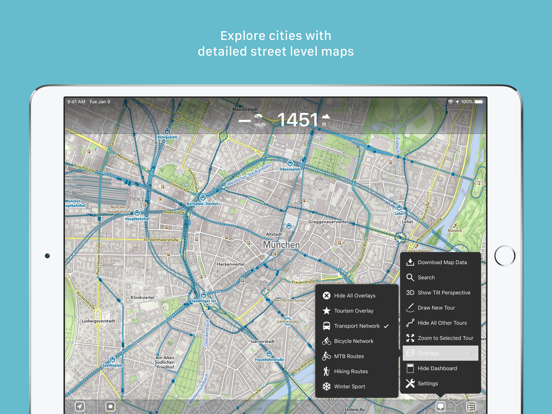
- For city travelers: City maps with tourist information
- For the connoisseur: Simply beautiful map to look at
3D tilt view
- Tilt the device in any direction to get a better impression of the terrain. More information on https://mapout.app.
Search feature
- Search for places, streets, mountains, etc. No internet connection required.
Map material
- MapOut is based on the OpenStreetMap project, the “Wikipedia of Maps” - you can make corrections and additions yourself on OpenStreetMap.org. The latest maps are delivered with periodic updates.
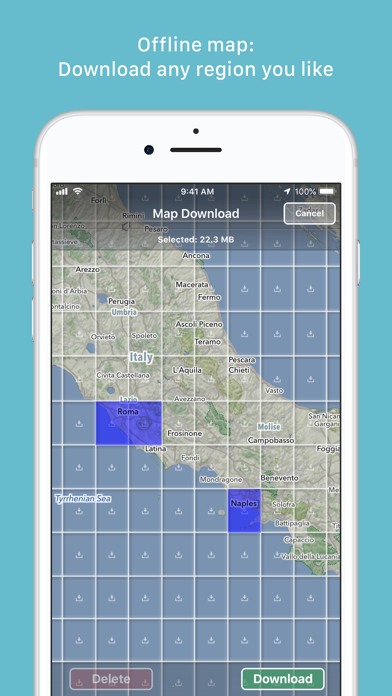
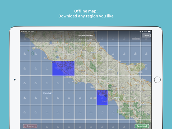
- Download the regions of your choice - the maps can now be displayed without an internet connection (offline map).
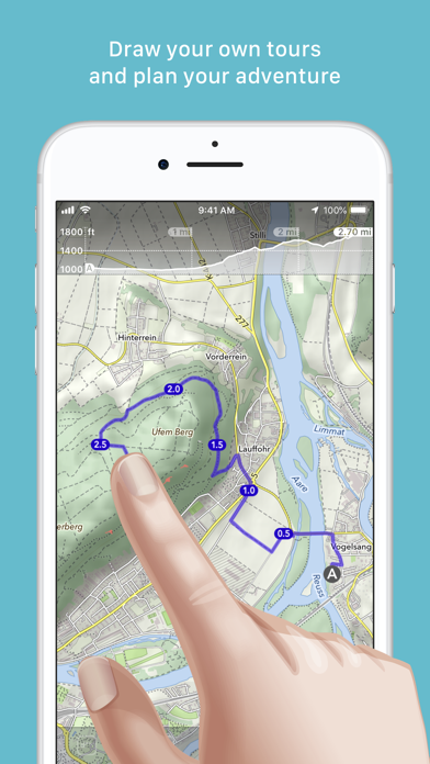
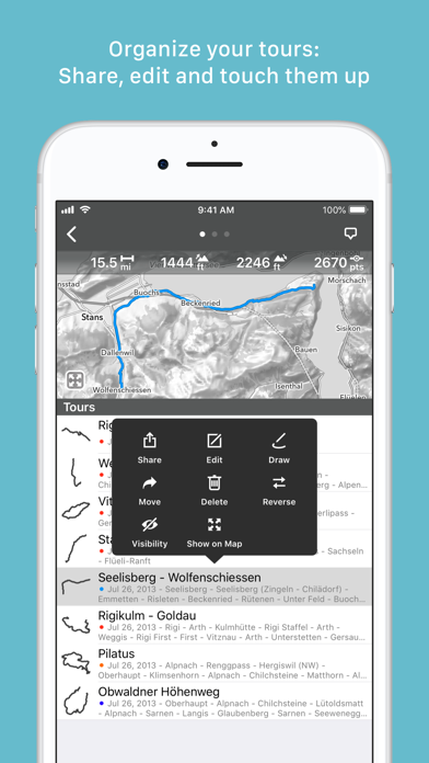
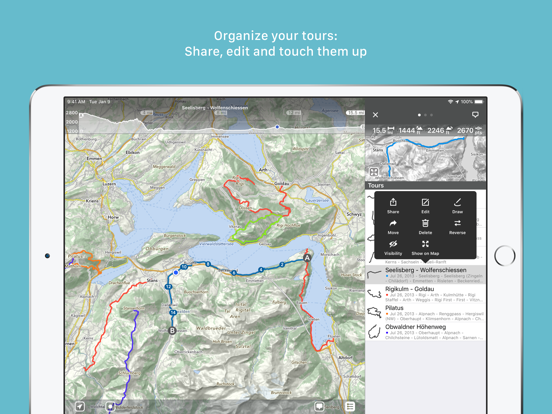
Tours
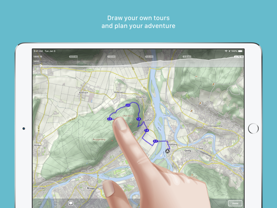
- Drawing: Draw your own routes and waypoints directly on the map. Retouch existing tours and imported GPX files or let them directly snap to the road network.
- Import: With a free “MapOut.me” account you can send directions by email to your device. GPS-Tours can be found as gpx or kml files on many websites with tips for hiking or biking (e.g. on www.gpsies.com)
Record: Take recordings of your own tours and share them with friends.
Information: Quick overview of each tour - length, altitude change, map section and route profile
Map view
- Fast map display (hardware accelerated)
- Step-free zoom, always a pixel-perfect map
- Topographical map with contour lines and shading
- Selectable overlays: Bike/hike/ski routes, sightseeing, public transport
Find all answers to your questions in our user manual: https://mapout.app/manual
Map data © OpenStreetMap contributors (https://www.openstreetmap.org/copyright)
Offline map covering the whole world for iPhone and iPad. Almost as beautiful as a paper map - only more versatile.
- For hikers: With an easy-to-read representation of the terrain, even in the furthest corners without internet
- For cyclists: With cycling route network, speed and distance display
- For city travelers: City maps with tourist information
- For the connoisseur: Simply beautiful map to look at
3D tilt view
- Tilt the device in any direction to get a better impression of the terrain. More information on https://mapout.app.
Search feature
- Search for places, streets, mountains, etc. No internet connection required.
Map material
- MapOut is based on the OpenStreetMap project, the “Wikipedia of Maps” - you can make corrections and additions yourself on OpenStreetMap.org. The latest maps are delivered with periodic updates.
- Download the regions of your choice - the maps can now be displayed without an internet connection (offline map).
Tours
- Drawing: Draw your own routes and waypoints directly on the map. Retouch existing tours and imported GPX files or let them directly snap to the road network.
- Import: With a free “MapOut.me” account you can send directions by email to your device. GPS-Tours can be found as gpx or kml files on many websites with tips for hiking or biking (e.g. on www.gpsies.com)
Record: Take recordings of your own tours and share them with friends.
Information: Quick overview of each tour - length, altitude change, map section and route profile
Map view
- Fast map display (hardware accelerated)
- Step-free zoom, always a pixel-perfect map
- Topographical map with contour lines and shading
- Selectable overlays: Bike/hike/ski routes, sightseeing, public transport
Find all answers to your questions in our user manual: https://mapout.app/manual
Map data © OpenStreetMap contributors (https://www.openstreetmap.org/copyright)
 このアプリはiPhone、iPadの両方に対応しています。
カテゴリー
ナビゲーション
ナビゲーション
リリース
2012/3/20
2012/3/20
更新
2021/9/4
2021/9/4
バージョン
3.4.9
3.4.9
言語
英語, ドイツ語
英語, ドイツ語
サイズ
74 MB
74 MB
条件
iPhone、iPod touch および iPad 互換 iOS 4.3 以降が必要 iPhone 5 用に最適化済み
iPhone、iPod touch および iPad 互換 iOS 4.3 以降が必要 iPhone 5 用に最適化済み
このバージョンの新機能
- various bug fixes
- various bug fixes
スクリーンショット - iPhone | iPad
スクリーンショット - iPhone | iPad
» 目的別iPhoneアプリ検索
- 辞書 » 日本語対応の辞書 » 英和辞典
- 学習 » 英単語 » 英会話 » クイズで楽しく
- スケジュール » 管理 » Googleカレンダー


Yahoo!乗換案内
Yahoo Japan Corp.無料
Google マップ - ナビ、乗換案内
Google LLC無料
Yahoo!カーナビ
Yahoo Japan Corp.無料
乗換NAVITIME(乗換ナビタイム) - 運行情報や路線図..
NAVITIME JAPAN CO.,LTD.無料
Yahoo! MAP-ヤフーマップ
Yahoo Japan Corp.無料
乗換案内
Jorudan Co.,Ltd.無料
賃貸物件検索 SUUMO(スーモ)でお部屋探し
Recruit Co.,Ltd.無料
NAVITIME(乗換と地図の総合ナビ)
NAVITIME JAPAN CO.,LTD.無料
NAVITIMEドライブサポーター - カーナビ&渋滞情報&..
NAVITIME JAPAN CO.,LTD.無料
お部屋探しはライフルホームズ賃貸・マンション・不動産物件検索
LIFULL Co., Ltd無料


CatchApp新着アプリレビュー
 日本縦断てつどうの旅」")
様々な楽しみ方で運転士として成長していく鉄道運転士育成RPG「プラチナ・トレイン(プラトレ) 日本縦断てつどうの旅」
2016-05-17 00:00

日本語にはない英語発音のリスニングを楽しく学べる「発音どっち?英語リスニング 」
2014-12-20 12:00

指先の瞬発力が試されるカジュアルゲーム「早撃ちパニック」をリリース!
2014-12-08 15:21
新着アプリ動画
-
 ¥1500
¥1500
-
 ¥600
¥600
-
 ¥3000
¥3000