


このアプリのYoutube動画がある場合はURLを送信してください。詳細 »
APPLICATION INFO - iPhoneアプリの詳細情報
Never miss a turn with NaviMaps: 3D GPS Navigation. MapmyIndia now brings the most accurate car navigation system trusted by Maruti Suzuki, Jaguar Land Rover, Toyota, Fiat, TATA & Mahindra to your device.
NaviMaps: 3D GPS Navigation, an interactive maps and navigation app with voice direction. Get detailed maps of India, Bangladesh, Nepal & Sri Lanka, powered by MapmyIndia. Save your mobile data as NaviMaps: 3D GPS Navigation doesn't require internet to function. With internet, get Live Traffic feed, Location & Route sharing via SMS, WhatsApp, Viber, Email & Facebook.
INSTALL NaviMaps: 3D GPS Navigation today to get access to all Pro-Guidance features for FREE for 7 Days.
Features Include:-
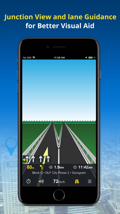
• Junction Views - Visual aid to the driver at road junctions.
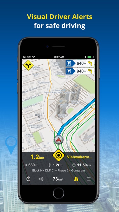
• Driver Alerts & Realistic Signposts - Visual driver alerts for better situational awareness.
• Live Turn-by-Turn voice guidance in English & 10 regional languages: Hindi, Kannada, Marathi, Punjabi, Bengali, Gujarati, Malayalam, Oriya, Tamil & Telugu*
• Text to Speech - NaviMaps speaks out place names during voice prompts.
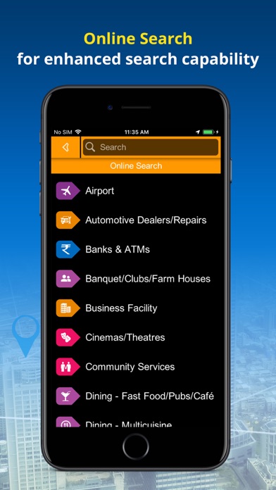
• Unified Search: Search EVERYTHING from one interface with colour coded visual references.
• Auto re-route navigation with voice will re-route you from the deviated course.*
• Varied POI, down to the house no., also locate Petrol Pumps & Parking Places along the route.*
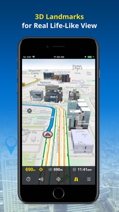
• Detailed map coverage, realistic 3D Landmark, terrain & city models for better recognition*
• FREE lifetime MAP UPDATES*
• NaviMaps: 3D GPS Navigation can be synced with your in-car navigation system, making it into a fully featured navigation system. NaviMaps supports connectivity with TATA motors, Pioneer AppRadio compatible devices*, ConnectNext Infotainment system and Jaguar Land Rover InControl™ Apps compatible vehicles*
• Offline maps, directions & local search on your device
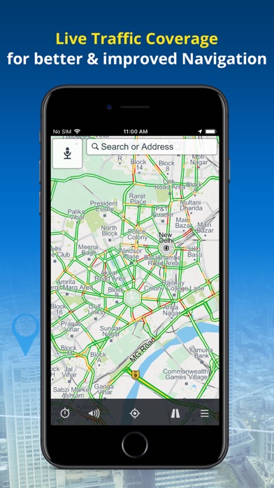
• Get up to 3 alternate driving routes & 1 pedestrian route. The route automatically updates you with Live Traffic (Internet required)
• Location & route sharing through WhatsApp, SMS, Viber, Email & Facebook
• Via internet, get live traffic & expected delay.
• Multi-Stop routing to plan trips for leisure or business
• Multi-touch map display
• Two-finger swipe down to return to map view from any page or menu
Maps:-
Map of India is split into 32 different states which you can download as per travel plan. Download, remove & re-download maps as often as they like.
NaviMaps is powered by MapmyIndia allowing you access to:-
• 4.6 Mn+ kms of roads connecting 7250+ towns & 6.5+ lakh villages
• 20.75 million+ points of interest across the country
• 6730+ 3D Landmarks & 2D footprints in 245 cities
• 10 million+ house numbers for last mile navigation in 190 cities
• Lane Guidance in 583 cities along with national stretches
NaviMaps in other Countries: SRI LANKA, NEPAL & BANGLADESH
Sri Lanka:
• 100000+ kms of roads connecting 265 cities at street level with 427 towns & villages
• 121000+ Points of Interest
• 90+ 3D Landmarks & 520000+ 2D footprints in 8 cities
• Lane Guidance in 5 cities
Nepal:
• 61 Cities at street level with 3945 towns & villages
• 52000+ Points of Interest
Bangladesh:
• 107 Cities at street level with 1000+ towns & villages
• 100000+ Points of Interest
• 250000+ 2D footprints
LIVE TRAFFIC Updates for the 31 cities including:
New Delhi, Bangalore, Mumbai, Gurgaon, Ghaziabad, Noida, Greater Noida, Faridabad, Navi Mumbai, Thane, Bhiwandi, Kalyan, Vasai-Virar, Ambarnath, Pune, Pimpri-Chinchwad, Chakan, Talegaon, Dehu, Secunderabad, Ahmedabad, Hyderabad, Chennai, Kolkata, Bidhan Nagar, Haora.
Install NaviMaps: 3D GPS Navigation today.
Note:
Continued use of ANY GPS application running in the background can significantly drain your phone’s battery. Using a charger while navigating is recommended.
* Requires purchase of Pro-Guidance in-app.
For any app related issues and feedback, please mail us on (navimaps@mapmyindia.co.in). We would love to hear from you.
NaviMaps: 3D GPS Navigation, an interactive maps and navigation app with voice direction. Get detailed maps of India, Bangladesh, Nepal & Sri Lanka, powered by MapmyIndia. Save your mobile data as NaviMaps: 3D GPS Navigation doesn't require internet to function. With internet, get Live Traffic feed, Location & Route sharing via SMS, WhatsApp, Viber, Email & Facebook.
INSTALL NaviMaps: 3D GPS Navigation today to get access to all Pro-Guidance features for FREE for 7 Days.
Features Include:-
• Junction Views - Visual aid to the driver at road junctions.
• Driver Alerts & Realistic Signposts - Visual driver alerts for better situational awareness.
• Live Turn-by-Turn voice guidance in English & 10 regional languages: Hindi, Kannada, Marathi, Punjabi, Bengali, Gujarati, Malayalam, Oriya, Tamil & Telugu*
• Text to Speech - NaviMaps speaks out place names during voice prompts.
• Unified Search: Search EVERYTHING from one interface with colour coded visual references.
• Auto re-route navigation with voice will re-route you from the deviated course.*
• Varied POI, down to the house no., also locate Petrol Pumps & Parking Places along the route.*
• Detailed map coverage, realistic 3D Landmark, terrain & city models for better recognition*
• FREE lifetime MAP UPDATES*
• NaviMaps: 3D GPS Navigation can be synced with your in-car navigation system, making it into a fully featured navigation system. NaviMaps supports connectivity with TATA motors, Pioneer AppRadio compatible devices*, ConnectNext Infotainment system and Jaguar Land Rover InControl™ Apps compatible vehicles*
• Offline maps, directions & local search on your device
• Get up to 3 alternate driving routes & 1 pedestrian route. The route automatically updates you with Live Traffic (Internet required)
• Location & route sharing through WhatsApp, SMS, Viber, Email & Facebook
• Via internet, get live traffic & expected delay.
• Multi-Stop routing to plan trips for leisure or business
• Multi-touch map display
• Two-finger swipe down to return to map view from any page or menu
Maps:-
Map of India is split into 32 different states which you can download as per travel plan. Download, remove & re-download maps as often as they like.
NaviMaps is powered by MapmyIndia allowing you access to:-
• 4.6 Mn+ kms of roads connecting 7250+ towns & 6.5+ lakh villages
• 20.75 million+ points of interest across the country
• 6730+ 3D Landmarks & 2D footprints in 245 cities
• 10 million+ house numbers for last mile navigation in 190 cities
• Lane Guidance in 583 cities along with national stretches
NaviMaps in other Countries: SRI LANKA, NEPAL & BANGLADESH
Sri Lanka:
• 100000+ kms of roads connecting 265 cities at street level with 427 towns & villages
• 121000+ Points of Interest
• 90+ 3D Landmarks & 520000+ 2D footprints in 8 cities
• Lane Guidance in 5 cities
Nepal:
• 61 Cities at street level with 3945 towns & villages
• 52000+ Points of Interest
Bangladesh:
• 107 Cities at street level with 1000+ towns & villages
• 100000+ Points of Interest
• 250000+ 2D footprints
LIVE TRAFFIC Updates for the 31 cities including:
New Delhi, Bangalore, Mumbai, Gurgaon, Ghaziabad, Noida, Greater Noida, Faridabad, Navi Mumbai, Thane, Bhiwandi, Kalyan, Vasai-Virar, Ambarnath, Pune, Pimpri-Chinchwad, Chakan, Talegaon, Dehu, Secunderabad, Ahmedabad, Hyderabad, Chennai, Kolkata, Bidhan Nagar, Haora.
Install NaviMaps: 3D GPS Navigation today.
Note:
Continued use of ANY GPS application running in the background can significantly drain your phone’s battery. Using a charger while navigating is recommended.
* Requires purchase of Pro-Guidance in-app.
For any app related issues and feedback, please mail us on (navimaps@mapmyindia.co.in). We would love to hear from you.
 このアプリはiPhone、iPadの両方に対応しています。
カテゴリー
ナビゲーション
ナビゲーション
リリース
2014/7/25
2014/7/25
更新
2016/11/28
2016/11/28
バージョン
2.1.5
2.1.5
言語
サイズ
43.7 MB
43.7 MB
条件
このバージョンの新機能
• V15.1 India and V6.0: Bangladesh, Nepal, Sri Lanka Maps (November, 2017)
• eLoc: integrated pan India
• Various bug fixes for Oreo
• Historical traffic speed patterns integrated for 24 cities pan India.
• Recent destinations, My Places, Contacts with ad
• V15.1 India and V6.0: Bangladesh, Nepal, Sri Lanka Maps (November, 2017)
• eLoc: integrated pan India
• Various bug fixes for Oreo
• Historical traffic speed patterns integrated for 24 cities pan India.
• Recent destinations, My Places, Contacts with ad
スクリーンショット - iPhone | iPad
スクリーンショット - iPhone | iPad
MapmyIndia の他のアプリ » もっと見る
» 目的別iPhoneアプリ検索
- 辞書 » 日本語対応の辞書 » 英和辞典
- 学習 » 英単語 » 英会話 » クイズで楽しく
- スケジュール » 管理 » Googleカレンダー


Yahoo!乗換案内
Yahoo Japan Corp.無料
Google マップ - ナビ、乗換案内
Google LLC無料
Yahoo!カーナビ
Yahoo Japan Corp.無料
乗換NAVITIME(乗換ナビタイム) - 運行情報や路線図..
NAVITIME JAPAN CO.,LTD.無料
Yahoo! MAP-ヤフーマップ
Yahoo Japan Corp.無料
乗換案内
Jorudan Co.,Ltd.無料
賃貸物件検索 SUUMO(スーモ)でお部屋探し
Recruit Co.,Ltd.無料
NAVITIME(乗換と地図の総合ナビ)
NAVITIME JAPAN CO.,LTD.無料
NAVITIMEドライブサポーター - カーナビ&渋滞情報&..
NAVITIME JAPAN CO.,LTD.無料
お部屋探しはライフルホームズ賃貸・マンション・不動産物件検索
LIFULL Co., Ltd無料


CatchApp新着アプリレビュー
 日本縦断てつどうの旅」")
様々な楽しみ方で運転士として成長していく鉄道運転士育成RPG「プラチナ・トレイン(プラトレ) 日本縦断てつどうの旅」
2016-05-17 00:00

日本語にはない英語発音のリスニングを楽しく学べる「発音どっち?英語リスニング 」
2014-12-20 12:00

指先の瞬発力が試されるカジュアルゲーム「早撃ちパニック」をリリース!
2014-12-08 15:21
新着アプリ動画
-
 ¥1500
¥1500
-
 ¥600
¥600
-
 ¥3000
¥3000