


このアプリのYoutube動画がある場合はURLを送信してください。詳細 »
APPLICATION INFO - iPhoneアプリの詳細情報
The Vaarkaart Friese Meren is the perfect app for when you go sailing on the Frisian Meren.
Ideal if you have rented a boat, but also for skipper and crew of sailing boats, motor boats and sloops on the Frisian Lakes. Even if you go sailing in a canoe or kayak or go fishing on the lakes of Friesland.
This app contains the DKW Vaarkaart Frisian lakes: a very detailed water chart that covers a large part of Friesland, from Stavoren to Grou.
Navigate with this water chart on the Heegermeer, Fluessen, Morra, Oudegaster Brekken, Zwarte en Witte Brekken, Sneekermeer, Coevorden, Tjeukemeer, Langweerderwiel, and Pikmeer / Wijde Ee.
With this app you can:
- always see where you are, how fast you are sailing and what your course is with the help of a GPS (internal or bluetooth).
- place and sail to a navigation waypoint using the course line, Course to Steer and Distance to Go.
- view your sailed tracks on the chart.
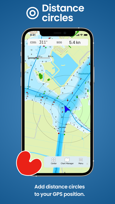
- show distance circles around your GPS position.
- Waterway network: View the information of the bridges, locks and waterways.
This is a very detailed chart with a scale of 1 m/pixel. This compares to about 1 in 3,000 on the screen. In total there are 3,393 waypoints on the DKW Vaarkaart Friese Meren, including buoys, marinas, moorings, Marrekrite berths, diesel filling stations, water sports campsites, mooring buoys, slobbers, rigging jetties and VHF channels.
With the detailed depth image from the Frisian Lakes Project in beautifully colored depth planes on the lakes and depth figures along the waterways. Developed by Stentec in collaboration with Province of Fryslân based on the most recent depth measurements.
Ideal if you have rented a boat, but also for skipper and crew of sailing boats, motor boats and sloops on the Frisian Lakes. Even if you go sailing in a canoe or kayak or go fishing on the lakes of Friesland.
This app contains the DKW Vaarkaart Frisian lakes: a very detailed water chart that covers a large part of Friesland, from Stavoren to Grou.
Navigate with this water chart on the Heegermeer, Fluessen, Morra, Oudegaster Brekken, Zwarte en Witte Brekken, Sneekermeer, Coevorden, Tjeukemeer, Langweerderwiel, and Pikmeer / Wijde Ee.
With this app you can:
- always see where you are, how fast you are sailing and what your course is with the help of a GPS (internal or bluetooth).
- place and sail to a navigation waypoint using the course line, Course to Steer and Distance to Go.
- view your sailed tracks on the chart.
- show distance circles around your GPS position.
- Waterway network: View the information of the bridges, locks and waterways.
This is a very detailed chart with a scale of 1 m/pixel. This compares to about 1 in 3,000 on the screen. In total there are 3,393 waypoints on the DKW Vaarkaart Friese Meren, including buoys, marinas, moorings, Marrekrite berths, diesel filling stations, water sports campsites, mooring buoys, slobbers, rigging jetties and VHF channels.
With the detailed depth image from the Frisian Lakes Project in beautifully colored depth planes on the lakes and depth figures along the waterways. Developed by Stentec in collaboration with Province of Fryslân based on the most recent depth measurements.
 このアプリはiPhone、iPadの両方に対応しています。
カテゴリー
ナビゲーション
ナビゲーション
リリース
2021/4/23
2021/4/23
更新
2021/7/21
2021/7/21
バージョン
1.2
1.2
言語
サイズ
110.8 MB
110.8 MB
条件
このバージョンの新機能
- Display of the waterway-network, and extra info on each specific location.
- Solution for some GPS problems.
- Display of the waterway-network, and extra info on each specific location.
- Solution for some GPS problems.
スクリーンショット - iPhone | iPad
スクリーンショット - iPhone | iPad
Stentec Software の他のアプリ » もっと見る
» 目的別iPhoneアプリ検索
- 辞書 » 日本語対応の辞書 » 英和辞典
- 学習 » 英単語 » 英会話 » クイズで楽しく
- スケジュール » 管理 » Googleカレンダー


CatchApp新着アプリレビュー
 日本縦断てつどうの旅」")
様々な楽しみ方で運転士として成長していく鉄道運転士育成RPG「プラチナ・トレイン(プラトレ) 日本縦断てつどうの旅」
2016-05-17 00:00

日本語にはない英語発音のリスニングを楽しく学べる「発音どっち?英語リスニング 」
2014-12-20 12:00

指先の瞬発力が試されるカジュアルゲーム「早撃ちパニック」をリリース!
2014-12-08 15:21
新着アプリ動画
-
 ¥1500
¥1500

-
 ¥600
¥600
-
 ¥3000
¥3000