


このアプリのYoutube動画がある場合はURLを送信してください。詳細 »
APPLICATION INFO - iPhoneアプリの詳細情報
Bluefield Incidents makes your emergency team on the ground as responsive as possible when seconds count.
Bluefield Incidents for ArcGIS gives you the same simple drawing and note-taking capabilities found in our popular app, Draw Maps for ArcGIS. Bluefield Incidents adds functionality specific to emergency management and incident management settings. For a new incident, staff members on the scene can make notes on the map which are shared with each other automatically as the notes are being made, map notes synchronized in near real time (multi-user notes). This can assist the team in numerous ways during an emergency while also making a permanent record in ArcGIS tied to the incident number.
Bluefield Incidents also serves as a great reporting mechanism. Send copies of the map to anyone with Draw Maps (either Draw Maps: Map Notes or Draw Maps for ArcGIS, both of which are free downloads on the App Store). Alternatively, send copies in KML format to anyone with Google Earth.
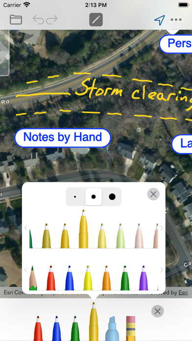
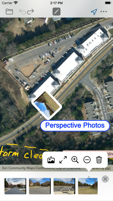
Bluefield Incidents gives you color pens and pencils to make sketches and take notes anywhere in the map. Add photos from different angles of the incident scene showing multiple perspectives. Take notes on each photo similar to the way notes are taken in the map. Add map pins to show important locations. Move around and zoom to different scales as you draw.
Your notes and photos are instantly viewable in ArcGIS Online. A web app can easily be setup in ArcGIS Online to show notes during an active incident in progress.
Features:
- Join new incidents while in the field
- Create new incidents if needed
- Draw and highlight in the map
- Place colored map pins in the map and add long form notes
- Place photos in the map
- Draw and highlight in the photos
- 72 colors
- Use the stencil to draw perfect shapes or labels
- Move and zoom the map as needed while you draw
- Works great with Apple Pencil
- Take your maps offline with Map Package Download
- Send images of your map drawings to other people
- Send copies as Draw Maps Documents to Draw Maps users
- Send KML
Common use cases:
- Traffic accidents
- Plane crashes
- Train derailments
- Structure fires
- Forest fires
- Storm damage
- Natural disasters
- Missing persons
- Crime scenes
- Property damage
- Graffiti and vandalism
- Insurance investigations
- Fire inspections
IMPORTANT: *REQUIRES* ArcGIS Online Login.
Bluefield Incidents for ArcGIS gives you the same simple drawing and note-taking capabilities found in our popular app, Draw Maps for ArcGIS. Bluefield Incidents adds functionality specific to emergency management and incident management settings. For a new incident, staff members on the scene can make notes on the map which are shared with each other automatically as the notes are being made, map notes synchronized in near real time (multi-user notes). This can assist the team in numerous ways during an emergency while also making a permanent record in ArcGIS tied to the incident number.
Bluefield Incidents also serves as a great reporting mechanism. Send copies of the map to anyone with Draw Maps (either Draw Maps: Map Notes or Draw Maps for ArcGIS, both of which are free downloads on the App Store). Alternatively, send copies in KML format to anyone with Google Earth.
Bluefield Incidents gives you color pens and pencils to make sketches and take notes anywhere in the map. Add photos from different angles of the incident scene showing multiple perspectives. Take notes on each photo similar to the way notes are taken in the map. Add map pins to show important locations. Move around and zoom to different scales as you draw.
Your notes and photos are instantly viewable in ArcGIS Online. A web app can easily be setup in ArcGIS Online to show notes during an active incident in progress.
Features:
- Join new incidents while in the field
- Create new incidents if needed
- Draw and highlight in the map
- Place colored map pins in the map and add long form notes
- Place photos in the map
- Draw and highlight in the photos
- 72 colors
- Use the stencil to draw perfect shapes or labels
- Move and zoom the map as needed while you draw
- Works great with Apple Pencil
- Take your maps offline with Map Package Download
- Send images of your map drawings to other people
- Send copies as Draw Maps Documents to Draw Maps users
- Send KML
Common use cases:
- Traffic accidents
- Plane crashes
- Train derailments
- Structure fires
- Forest fires
- Storm damage
- Natural disasters
- Missing persons
- Crime scenes
- Property damage
- Graffiti and vandalism
- Insurance investigations
- Fire inspections
IMPORTANT: *REQUIRES* ArcGIS Online Login.
 このアプリはiPhone、iPadの両方に対応しています。
カテゴリー
ナビゲーション
ナビゲーション
リリース
2021/12/20
2021/12/20
バージョン
1.0
1.0
言語
サイズ
78.8 MB
78.8 MB
条件
スクリーンショット - iPhone | iPad
スクリーンショット - iPhone | iPad
Bluefield GIS, Inc. の他のアプリ » もっと見る
» 目的別iPhoneアプリ検索
- 辞書 » 日本語対応の辞書 » 英和辞典
- 学習 » 英単語 » 英会話 » クイズで楽しく
- スケジュール » 管理 » Googleカレンダー


Yahoo!乗換案内
Yahoo Japan Corp.無料
Google マップ - ナビ、乗換案内
Google LLC無料
Yahoo!カーナビ
Yahoo Japan Corp.無料
乗換NAVITIME(乗換ナビタイム) - 運行情報や路線図..
NAVITIME JAPAN CO.,LTD.無料
Yahoo! MAP-ヤフーマップ
Yahoo Japan Corp.無料
乗換案内
Jorudan Co.,Ltd.無料
賃貸物件検索 SUUMO(スーモ)でお部屋探し
Recruit Co.,Ltd.無料
NAVITIME(乗換と地図の総合ナビ)
NAVITIME JAPAN CO.,LTD.無料
NAVITIMEドライブサポーター - カーナビ&渋滞情報&..
NAVITIME JAPAN CO.,LTD.無料
お部屋探しはライフルホームズ賃貸・マンション・不動産物件検索
LIFULL Co., Ltd無料


CatchApp新着アプリレビュー
 日本縦断てつどうの旅」")
様々な楽しみ方で運転士として成長していく鉄道運転士育成RPG「プラチナ・トレイン(プラトレ) 日本縦断てつどうの旅」
2016-05-17 00:00

日本語にはない英語発音のリスニングを楽しく学べる「発音どっち?英語リスニング 」
2014-12-20 12:00

指先の瞬発力が試されるカジュアルゲーム「早撃ちパニック」をリリース!
2014-12-08 15:21
新着アプリ動画
-
 ¥1500
¥1500
-
 ¥600
¥600
-
 ¥3000
¥3000