


このアプリのYoutube動画がある場合はURLを送信してください。詳細 »
APPLICATION INFO - iPhoneアプリの詳細情報
Many people have dreamed of traveling the world and choose to bury their dreams for a variety of reasons. Come and visit the Globe Earth~
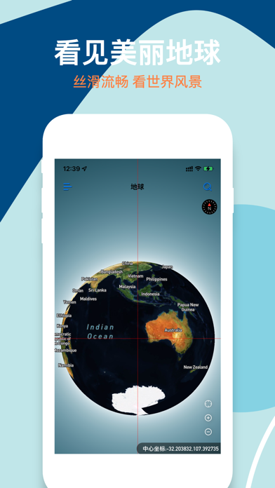
Globe Earth allows you to hold a magical globe, which is as smooth and small as a globe, and as real and clear as our earth.
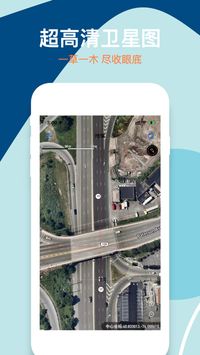
Globe Earth provides map zoom levels 0-22, using de-cloud data from NASA MODIS satellites at zoom levels 0-8.
Maxar satellite imagery and NASA/USGS Landsat 5 and 7 imagery are mainly used in limited locations at zoom levels 9-12.
Use a combination of open and proprietary sources at zoom level 13+, including Maxar's Vivid product for most of the world, Nearmap aerial imagery of US cities, and open aerial imagery from Denmark, France, Germany, and elsewhere.
Globe Earth satellite images come from a variety of sources, and the original images are color corrected to look realistic.
In addition to ultra-high-definition satellite images, we also provide other easy-to-use features:
- Search: Search anywhere in the world at will
- World Street View: HD panoramic street view maps of more than 200 countries and regions around the world
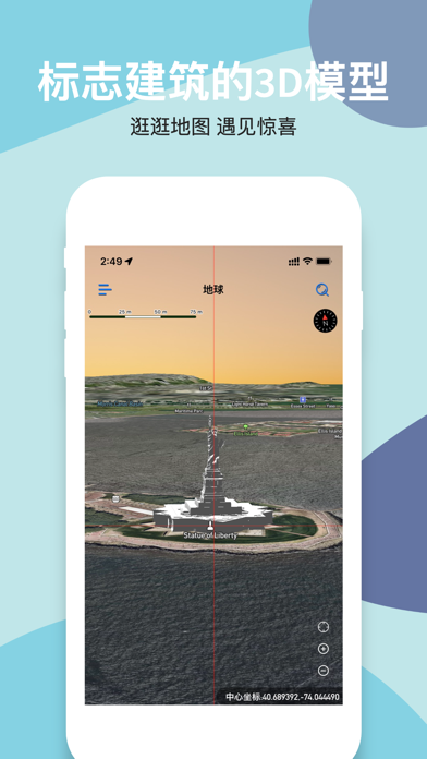
- Classic building models: For some scenic spots, we provide 3D models based on real buildings, look for them~
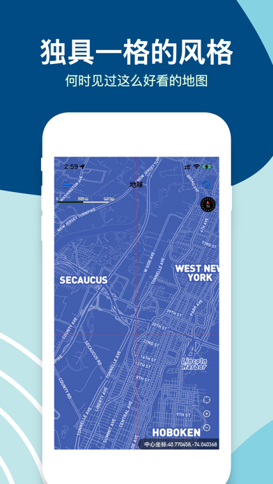
- Map style switching: Tired of satellite images? There are other styles for you to switch, and we will provide more styles in the future
- Navigation: Although this is not our main purpose, we still provide a complete basic navigation function for the convenience of users.
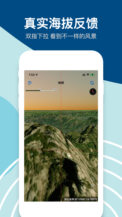
- Real altitude: When you are in satellite image mode, pull down with two fingers to switch the camera from the sky to the ground. During the sliding process, the altitude will be reflected in the map in real time, try it out~
- Supports multiple latitude and longitude formats: copied a latitude and longitude from somewhere else? Feel free to paste in the search bar and we'll automatically recognize the different formats and show you the point.
- Favorite places: During your browsing process, if you come across an interesting place that you like, long press to save it, and you can view and go to it at any time in the future.
- A variety of custom settings: We provide a lot of custom content, you can set them according to your situation.
The surprises that Globe Earth brings to you may not only stop there, but there may also be shortcomings. Users are welcome to give us feedback in a timely manner. Any suggestions can be sent to iamldj@163.com.
Globe Earth allows you to hold a magical globe, which is as smooth and small as a globe, and as real and clear as our earth.
Globe Earth provides map zoom levels 0-22, using de-cloud data from NASA MODIS satellites at zoom levels 0-8.
Maxar satellite imagery and NASA/USGS Landsat 5 and 7 imagery are mainly used in limited locations at zoom levels 9-12.
Use a combination of open and proprietary sources at zoom level 13+, including Maxar's Vivid product for most of the world, Nearmap aerial imagery of US cities, and open aerial imagery from Denmark, France, Germany, and elsewhere.
Globe Earth satellite images come from a variety of sources, and the original images are color corrected to look realistic.
In addition to ultra-high-definition satellite images, we also provide other easy-to-use features:
- Search: Search anywhere in the world at will
- World Street View: HD panoramic street view maps of more than 200 countries and regions around the world
- Classic building models: For some scenic spots, we provide 3D models based on real buildings, look for them~
- Map style switching: Tired of satellite images? There are other styles for you to switch, and we will provide more styles in the future
- Navigation: Although this is not our main purpose, we still provide a complete basic navigation function for the convenience of users.
- Real altitude: When you are in satellite image mode, pull down with two fingers to switch the camera from the sky to the ground. During the sliding process, the altitude will be reflected in the map in real time, try it out~
- Supports multiple latitude and longitude formats: copied a latitude and longitude from somewhere else? Feel free to paste in the search bar and we'll automatically recognize the different formats and show you the point.
- Favorite places: During your browsing process, if you come across an interesting place that you like, long press to save it, and you can view and go to it at any time in the future.
- A variety of custom settings: We provide a lot of custom content, you can set them according to your situation.
The surprises that Globe Earth brings to you may not only stop there, but there may also be shortcomings. Users are welcome to give us feedback in a timely manner. Any suggestions can be sent to iamldj@163.com.
カテゴリー
ナビゲーション
ナビゲーション
リリース
2022/5/12
2022/5/12
更新
2022/7/8
2022/7/8
バージョン
2.2.0
2.2.0
言語
サイズ
95.5 MB
95.5 MB
条件
このバージョンの新機能
1.优化地球转动体验。
1.优化地球转动体验。
スクリーンショット - iPhone | iPad
スクリーンショット - iPhone | iPad
大靖 刘 の他のアプリ » もっと見る
» 目的別iPhoneアプリ検索
- 辞書 » 日本語対応の辞書 » 英和辞典
- 学習 » 英単語 » 英会話 » クイズで楽しく
- スケジュール » 管理 » Googleカレンダー


Yahoo!乗換案内
Yahoo Japan Corp.無料
Google マップ - ナビ、乗換案内
Google LLC無料
Yahoo!カーナビ
Yahoo Japan Corp.無料
乗換NAVITIME(乗換ナビタイム) - 運行情報や路線図..
NAVITIME JAPAN CO.,LTD.無料
Yahoo! MAP-ヤフーマップ
Yahoo Japan Corp.無料
乗換案内
Jorudan Co.,Ltd.無料
賃貸物件検索 SUUMO(スーモ)でお部屋探し
Recruit Co.,Ltd.無料
NAVITIME(乗換と地図の総合ナビ)
NAVITIME JAPAN CO.,LTD.無料
NAVITIMEドライブサポーター - カーナビ&渋滞情報&..
NAVITIME JAPAN CO.,LTD.無料
お部屋探しはライフルホームズ賃貸・マンション・不動産物件検索
LIFULL Co., Ltd無料


CatchApp新着アプリレビュー
 日本縦断てつどうの旅」")
様々な楽しみ方で運転士として成長していく鉄道運転士育成RPG「プラチナ・トレイン(プラトレ) 日本縦断てつどうの旅」
2016-05-17 00:00

日本語にはない英語発音のリスニングを楽しく学べる「発音どっち?英語リスニング 」
2014-12-20 12:00

指先の瞬発力が試されるカジュアルゲーム「早撃ちパニック」をリリース!
2014-12-08 15:21
新着アプリ動画
-
 ¥1500
¥1500
-
 ¥600
¥600
-
 ¥3000
¥3000