


このアプリのYoutube動画がある場合はURLを送信してください。詳細 »
APPLICATION INFO - iPhoneアプリの詳細情報
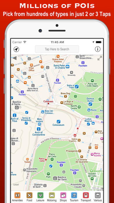
Poison Maps (“POIs on Maps”) is the ultimate app for finding Points of Interest anywhere in the world. It includes millions of POIs and routes, all stored on your device for use even when offline.
The app contains every possible category of POI: food, hotels, banks, toilets, fuel stations, tourist attractions, leisure, parking, shops, hills, towns, transport, hospitals, churches, schools, libraries, civic buildings, rescue services, and much much more.
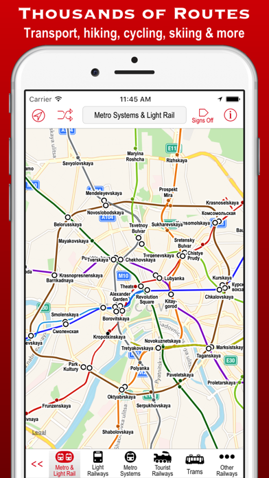
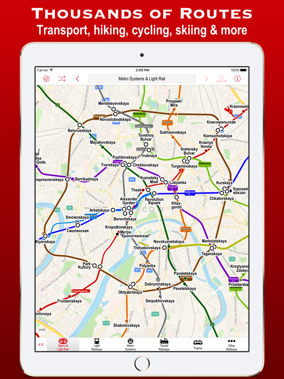
It also contains 4 million miles of colour-coded routes, such as railways, subway maps, bus routes, cycle routes, hiking trails and ski pistes. The POIs and routes are all taken from the fantastic OpenStreetMap project.
The app includes many unique features:
• a toolbar at the bottom of the screen that allows you to display what you want in just 2 or 3 taps;
• signs pointing to offscreen POIs, so that you never miss a nearby POI;
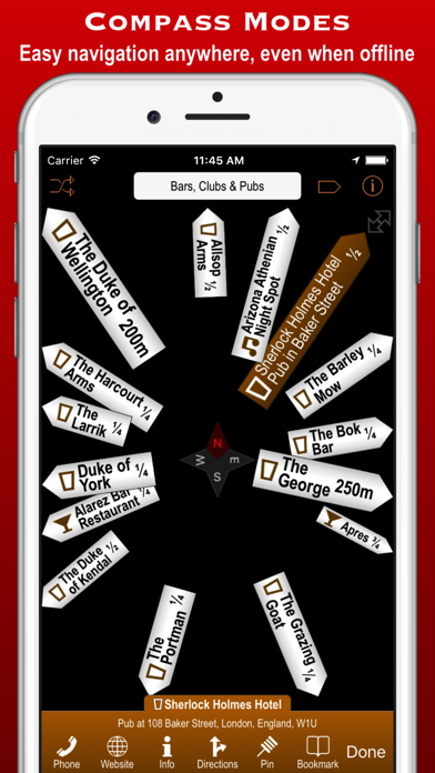
• compass, radar and scanner modes that display the nearest POIs in different ways;
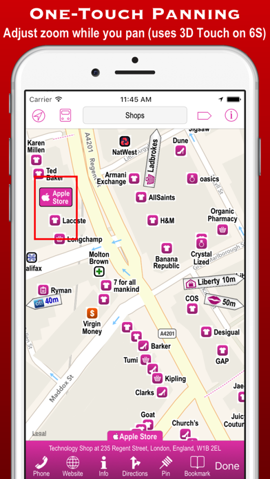
• a unique gesture that allows rapid panning by temporarily zooming out (using 3D Touch when available);
• back and forward buttons that help you retrace what you have looked at (like on a browser);
• an Apple Watch app that shows what you want in only a few taps (or just one tap of the complication);
Compass mode simply shows signs to the POIs. This is particularly useful when you just want to know what is around you or which way to head, and you haven’t got time to inspect a map, such as when cycling or hiking. It also works offline and is perfect for people who hate maps: they just follow the sign to where they want to go. It is also great at viewpoints to identify what hills, towns and structures you can see.
Radar mode and Scanner modes are similar but also include a map that rotates around the current position. They include radar “rings” to show the distances from the current position. Scanner mode uniquely positions the GPS dot at the bottom of the screen so that you can see much more information in the direction that you are pointing.
The unique panning gesture requires just one touch of one finger instead of the multi-finger gymnastics required by the traditional “pinch to zoom” approach (although that is still available). It also provides a quick way of zooming out and back in again when you are not sure what area the map is showing. It is a brilliant and completely original use of 3D Touch but also works fine on iPhones without it (using a long touch).
The Apple Watch app also allows you to select any category in just a few taps. When you have selected a category then the nearest POIs are shown on a mini-map with the details listed below. The watch app also provides navigation to a POI, and you can even phone a POI from the watch!
These are just some of the unique aspects of the app. All the usual map features are also provided, such as super-fast searching, directions, bookmarks, POI information, favouriting of brands, and much more. You can even create your own POIs, such as where you parked your car.
Note: This is the full global version – if you want to give the app a try first then please click on the 'Related' link above and install one of the regional versions. Not only can you try the app for free, but these versions only take up about the same space as 2 or 3 music albums.
The app contains every possible category of POI: food, hotels, banks, toilets, fuel stations, tourist attractions, leisure, parking, shops, hills, towns, transport, hospitals, churches, schools, libraries, civic buildings, rescue services, and much much more.
It also contains 4 million miles of colour-coded routes, such as railways, subway maps, bus routes, cycle routes, hiking trails and ski pistes. The POIs and routes are all taken from the fantastic OpenStreetMap project.
The app includes many unique features:
• a toolbar at the bottom of the screen that allows you to display what you want in just 2 or 3 taps;
• signs pointing to offscreen POIs, so that you never miss a nearby POI;
• compass, radar and scanner modes that display the nearest POIs in different ways;
• a unique gesture that allows rapid panning by temporarily zooming out (using 3D Touch when available);
• back and forward buttons that help you retrace what you have looked at (like on a browser);
• an Apple Watch app that shows what you want in only a few taps (or just one tap of the complication);
Compass mode simply shows signs to the POIs. This is particularly useful when you just want to know what is around you or which way to head, and you haven’t got time to inspect a map, such as when cycling or hiking. It also works offline and is perfect for people who hate maps: they just follow the sign to where they want to go. It is also great at viewpoints to identify what hills, towns and structures you can see.
Radar mode and Scanner modes are similar but also include a map that rotates around the current position. They include radar “rings” to show the distances from the current position. Scanner mode uniquely positions the GPS dot at the bottom of the screen so that you can see much more information in the direction that you are pointing.
The unique panning gesture requires just one touch of one finger instead of the multi-finger gymnastics required by the traditional “pinch to zoom” approach (although that is still available). It also provides a quick way of zooming out and back in again when you are not sure what area the map is showing. It is a brilliant and completely original use of 3D Touch but also works fine on iPhones without it (using a long touch).
The Apple Watch app also allows you to select any category in just a few taps. When you have selected a category then the nearest POIs are shown on a mini-map with the details listed below. The watch app also provides navigation to a POI, and you can even phone a POI from the watch!
These are just some of the unique aspects of the app. All the usual map features are also provided, such as super-fast searching, directions, bookmarks, POI information, favouriting of brands, and much more. You can even create your own POIs, such as where you parked your car.
Note: This is the full global version – if you want to give the app a try first then please click on the 'Related' link above and install one of the regional versions. Not only can you try the app for free, but these versions only take up about the same space as 2 or 3 music albums.
 このアプリはiPhone、iPadの両方に対応しています。
カテゴリー
ナビゲーション
ナビゲーション
リリース
2013/1/14
2013/1/14
更新
2018/4/4
2018/4/4
バージョン
3.0.8
3.0.8
言語
英語
英語
サイズ
1345.2 MB
1345.2 MB
条件
iPhone、iPod touch および iPad 互換 iOS 5.0 以降が必要 iPhone 5 用に最適化済み
iPhone、iPod touch および iPad 互換 iOS 5.0 以降が必要 iPhone 5 用に最適化済み
このバージョンの新機能
Now compatible with iPhone X and Apple Watch 3.
Updated with the latest data from OpenStreetMap: Now almost 30 million POIs and 4 million miles of routes for use even when offline!
Now compatible with iPhone X and Apple Watch 3.
Updated with the latest data from OpenStreetMap: Now almost 30 million POIs and 4 million miles of routes for use even when offline!
スクリーンショット - iPhone | iPad
スクリーンショット - iPhone | iPad
CCS Ltd の他のアプリ » もっと見る
» 目的別iPhoneアプリ検索
- 辞書 » 日本語対応の辞書 » 英和辞典
- 学習 » 英単語 » 英会話 » クイズで楽しく
- スケジュール » 管理 » Googleカレンダー


Yahoo!乗換案内
Yahoo Japan Corp.無料
Google マップ - ナビ、乗換案内
Google LLC無料
Yahoo!カーナビ
Yahoo Japan Corp.無料
乗換NAVITIME(乗換ナビタイム) - 運行情報や路線図..
NAVITIME JAPAN CO.,LTD.無料
Yahoo! MAP-ヤフーマップ
Yahoo Japan Corp.無料
乗換案内
Jorudan Co.,Ltd.無料
賃貸物件検索 SUUMO(スーモ)でお部屋探し
Recruit Co.,Ltd.無料
NAVITIME(乗換と地図の総合ナビ)
NAVITIME JAPAN CO.,LTD.無料
NAVITIMEドライブサポーター - カーナビ&渋滞情報&..
NAVITIME JAPAN CO.,LTD.無料
お部屋探しはライフルホームズ賃貸・マンション・不動産物件検索
LIFULL Co., Ltd無料


CatchApp新着アプリレビュー
 日本縦断てつどうの旅」")
様々な楽しみ方で運転士として成長していく鉄道運転士育成RPG「プラチナ・トレイン(プラトレ) 日本縦断てつどうの旅」
2016-05-17 00:00

日本語にはない英語発音のリスニングを楽しく学べる「発音どっち?英語リスニング 」
2014-12-20 12:00

指先の瞬発力が試されるカジュアルゲーム「早撃ちパニック」をリリース!
2014-12-08 15:21
新着アプリ動画
-
 ¥1500
¥1500
-
 ¥600
¥600
-
 ¥3000
¥3000