


このアプリのYoutube動画がある場合はURLを送信してください。詳細 »
APPLICATION INFO - iPhoneアプリの詳細情報
Get maps in high resolution of National Park Service parks and US Geological Survey topography quadrangles of Montana, Idaho and Wyoming on your iPhone and iPad for GPS** and offline use!
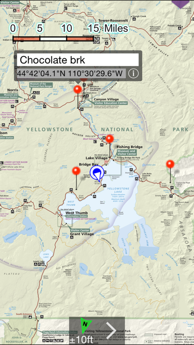
NP Maps Yellowstone app provides official NPS maps of Yellowstone National Park, Grand Teton National Park and more for you to see your location on them realtime. Plus, being designed for offline use, NP Maps Yellowstone can download official USGS topographic maps for all of the USA and island territories.*
This app is priceless for road trips, hikes, camping, exploring, planning and much more! Because many of these wilderness regions have no data service, select and download maps now or while online for your travels so you can enjoy using this app as it was intended: no internet connection. And, this app can detect internet service and automatically install USGS topography or NPS map for your current location if not already done.
Logical and intuitive to use. Park and topography maps are geospatially integrated with Apple Maps for a familiar interface and for navigating a visual catalog of maps. A marvelous index into an extensive library covering all of ID, MT, and WY states allows you to select maps for install all with a simple touch along your planned route of travel.
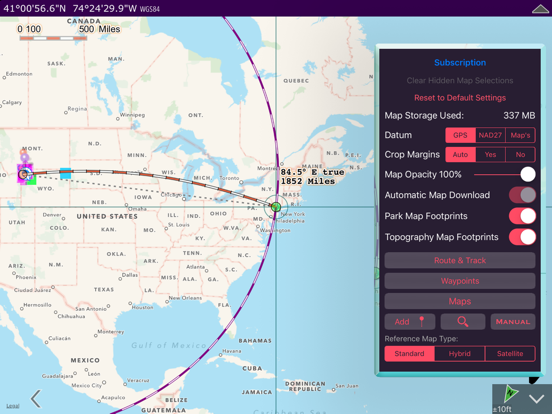
Purchase a subscription period for unlimited downloading of more NPS and USGS maps. A subscription stops ads and doesn't auto-renew. The first several map download are complementary.
Features:
• Preloaded with Yellowstone and Grand Teton NPS maps and two 100k scale USGS topography maps covering Yellowstone.
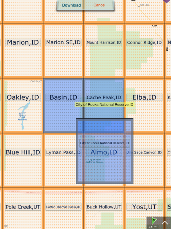
• Access a library of 150 NPS, over 60,000+ USGS & US Forest Service maps
• Full rendering high resolution maps
• Find geographic features worldwide with a powerful geo-code search
• Waypoints with Augmented Reality finder
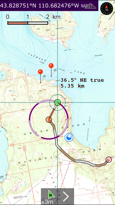
• Route path creation
• Track/bread-crumbs GPS path recording**
• Shows your current GPS location**
• Dual mode ruler with orthographic line and path measuring
• Full app usability while maps download in the background
• Footprint grid index with quadrangle names for visual map selection
• Aligns differing map datums to the WGS84/GPS location
• Automatic map download for your current location
• Miles, Feet, Kilometers, Meters, Nautical Miles units
• MGRS, UTM and geodetic Latitude and Longitude coordinate formats.
• Import and export waypoints using GPX format, some support of KLM
• Detailed integrated help
• Supports rotation and follows heading map orientations
• No need for cellular service to use installed maps
• A subscription allows for more map downloads, and also stops all advertisements
• Email and SMS text waypoints, tracks and routes as GPX files, with subscription purchase
* Not preloaded with all maps. WiFi recommended for downloading map quadrangles. First several map downloads are complementary. Downloading queue does cap to around 25 maps.
** Continued use of GPS running in the background can dramatically decrease battery life.
Location and AR features won't function for iPod and iPad models without GPS hardware.
NP Maps Yellowstone app provides official NPS maps of Yellowstone National Park, Grand Teton National Park and more for you to see your location on them realtime. Plus, being designed for offline use, NP Maps Yellowstone can download official USGS topographic maps for all of the USA and island territories.*
This app is priceless for road trips, hikes, camping, exploring, planning and much more! Because many of these wilderness regions have no data service, select and download maps now or while online for your travels so you can enjoy using this app as it was intended: no internet connection. And, this app can detect internet service and automatically install USGS topography or NPS map for your current location if not already done.
Logical and intuitive to use. Park and topography maps are geospatially integrated with Apple Maps for a familiar interface and for navigating a visual catalog of maps. A marvelous index into an extensive library covering all of ID, MT, and WY states allows you to select maps for install all with a simple touch along your planned route of travel.
Purchase a subscription period for unlimited downloading of more NPS and USGS maps. A subscription stops ads and doesn't auto-renew. The first several map download are complementary.
Features:
• Preloaded with Yellowstone and Grand Teton NPS maps and two 100k scale USGS topography maps covering Yellowstone.
• Access a library of 150 NPS, over 60,000+ USGS & US Forest Service maps
• Full rendering high resolution maps
• Find geographic features worldwide with a powerful geo-code search
• Waypoints with Augmented Reality finder
• Route path creation
• Track/bread-crumbs GPS path recording**
• Shows your current GPS location**
• Dual mode ruler with orthographic line and path measuring
• Full app usability while maps download in the background
• Footprint grid index with quadrangle names for visual map selection
• Aligns differing map datums to the WGS84/GPS location
• Automatic map download for your current location
• Miles, Feet, Kilometers, Meters, Nautical Miles units
• MGRS, UTM and geodetic Latitude and Longitude coordinate formats.
• Import and export waypoints using GPX format, some support of KLM
• Detailed integrated help
• Supports rotation and follows heading map orientations
• No need for cellular service to use installed maps
• A subscription allows for more map downloads, and also stops all advertisements
• Email and SMS text waypoints, tracks and routes as GPX files, with subscription purchase
* Not preloaded with all maps. WiFi recommended for downloading map quadrangles. First several map downloads are complementary. Downloading queue does cap to around 25 maps.
** Continued use of GPS running in the background can dramatically decrease battery life.
Location and AR features won't function for iPod and iPad models without GPS hardware.
 このアプリはiPhone、iPadの両方に対応しています。
カテゴリー
旅行
旅行
リリース
2015/7/31
2015/7/31
更新
2016/5/27
2016/5/27
バージョン
8.0
8.0
言語
サイズ
34.6 MB
34.6 MB
条件
このバージョンの新機能
• New PDF rendering engine that is faster and correctly displays the latest USGS USTopo series.
• Map viewing rewind and forward buttons.
• 100% Google free – No advertisements nor ad trackers.
• New PDF rendering engine that is faster and correctly displays the latest USGS USTopo series.
• Map viewing rewind and forward buttons.
• 100% Google free – No advertisements nor ad trackers.
スクリーンショット - iPhone | iPad
スクリーンショット - iPhone | iPad
» 目的別iPhoneアプリ検索
- 辞書 » 日本語対応の辞書 » 英和辞典
- 学習 » 英単語 » 英会話 » クイズで楽しく
- スケジュール » 管理 » Googleカレンダー


Google Earth
Google LLC無料
じゃらん
Recruit Co.,Ltd.無料
楽天トラベル
Rakuten Travel Inc.無料
ホテルズドットコム - 国内・海外のホテルをお得に予約
Hotels.com無料
ANA
ANA (All Nippon Airways)無料
アトラクション待ち時間
NORIHIKO HAYASAKA無料
エクスペディア - ホテル予約、格安航空券&現地ツアー予約
Expedia, Inc.無料
まっぷるリンク
Shobunsha Publications, Inc.無料
週刊じゃらん -旬の観光・グルメ・宿情報をまとめ読み
Recruit Co.,Ltd.無料
ホテル予約 厳選20社 旅比較ねっと
BIGLOBE Inc.無料


CatchApp新着アプリレビュー
 日本縦断てつどうの旅」")
様々な楽しみ方で運転士として成長していく鉄道運転士育成RPG「プラチナ・トレイン(プラトレ) 日本縦断てつどうの旅」
2016-05-17 00:00

日本語にはない英語発音のリスニングを楽しく学べる「発音どっち?英語リスニング 」
2014-12-20 12:00

指先の瞬発力が試されるカジュアルゲーム「早撃ちパニック」をリリース!
2014-12-08 15:21
新着アプリ動画
-
 ¥1500
¥1500
-
 ¥600
¥600
-
 ¥3000
¥3000