


このアプリのYoutube動画がある場合はURLを送信してください。詳細 »
APPLICATION INFO - iPhoneアプリの詳細情報
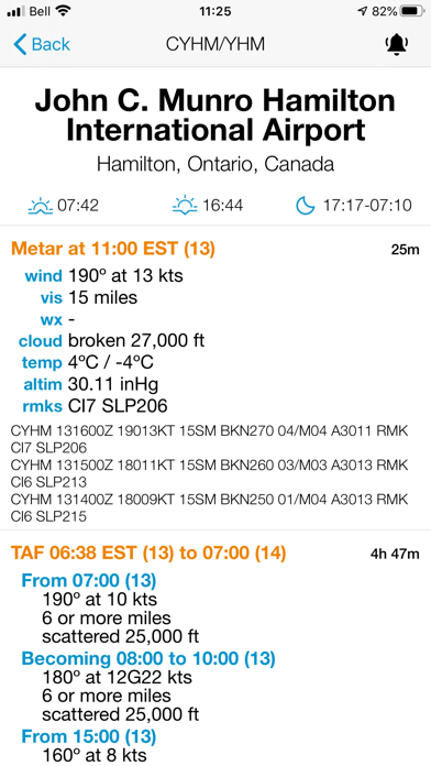
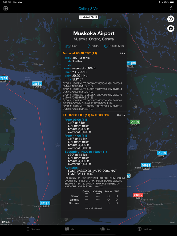
• View METARs and TAFs for thousands of airports around the world
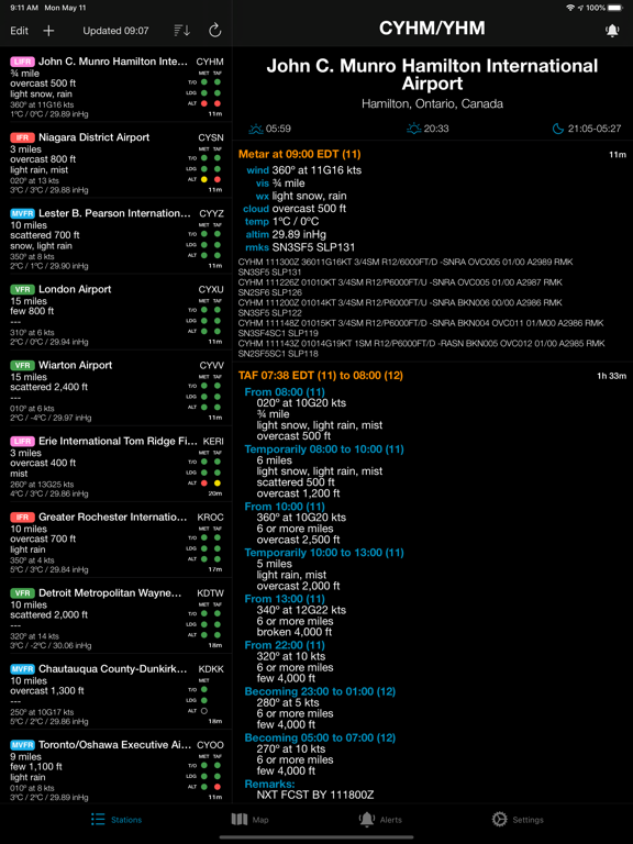
• Tells you if your airports are above, at, or below your custom minimums for takeoff, landing, and alternate
• Create custom alerts to be notified as soon as the weather changes (utilizes push notifications)
• Customize visibility, wind speed, altimeter setting, and temperature units
• Option to display information as either translated or raw
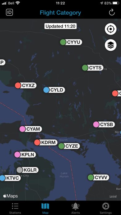
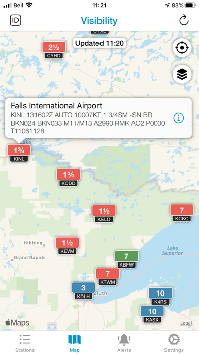
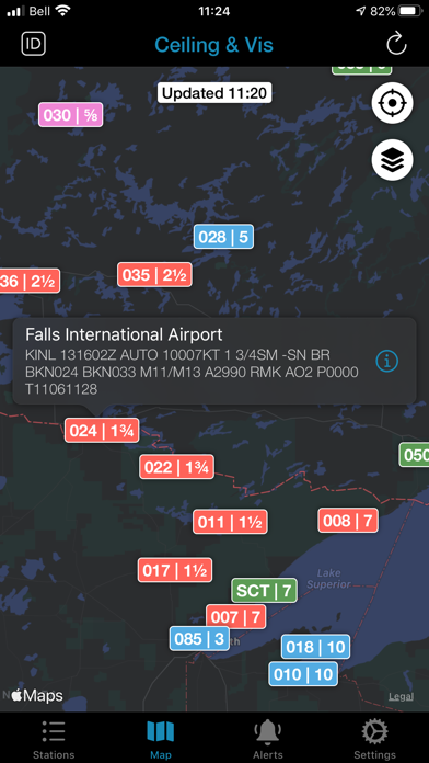
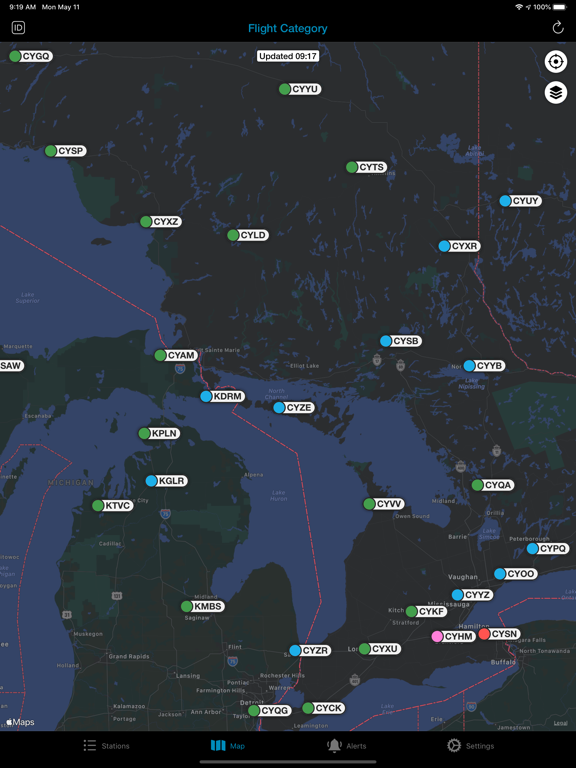
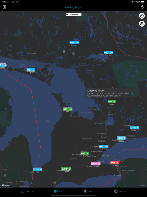
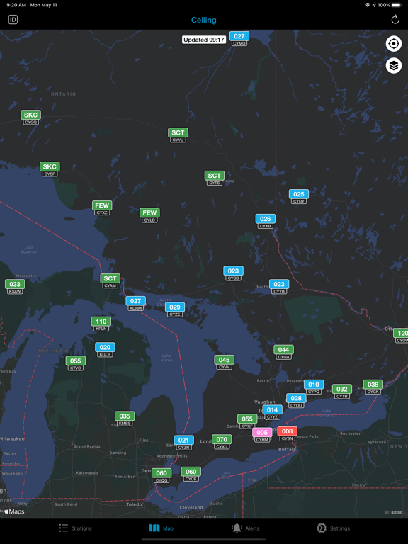
• Map view with flight category, ceiling, and visibility
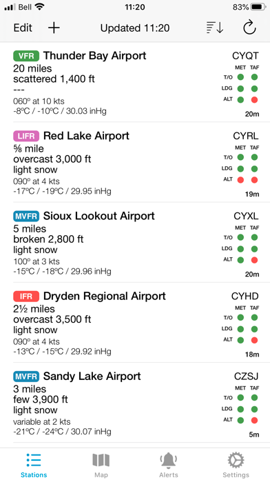
View your own personalized list of airports or weather stations and quickly determine if they are above or below your takeoff, landing, or alternate minimums. No more digging through TAFs to see if your favourite alternate will hold - if it's green, it's good for the duration of the TAF! If it's yellow, it's at minimums. If it's red, the weather goes below your minimums at some point during the forecast.
Minimums can be completely customized based on ceiling and visibility and is useful for all pilots, from airline to student. Simply set your personal, company, or legal limits for all of your airports, and quickly see which ones will work. You also have complete control over how TEMPO and PROB conditions should affect this analysis. Please note that minimums must be set manually by each user - a database of IFR minimums is not included in the app. However, with Data Sharing enabled, the app can suggest commonly used minimums for each airport.
Set up alerts that will notify you when the weather meets your own custom criteria. For example, you might ask Minimums to alert you when the visibility at a certain airport goes above 1 mile. Or maybe the ceiling at your destination is 300 feet and the minimums are 500 feet. Just create an alert to tell you when the ceiling goes above your desired value. Minimums uses push notifications so you don't have to constantly refresh the app. As soon as we detect your criteria has been met, we'll send your phone a notification letting you know. Alerts are currently available for ceiling, visibility, flight category (VFR, MVFR, IFR, LIFR), lowest cloud layer, and new metar issued.
Units can be customized as follows:
- Visibility (miles or meters)
- Wind Speed (knots or meters per second)
- Pressure (inches of mercury or hectopascals)
- Temperature (celsius or fahrenheit)
- Time (UTC or Local)
- Metars/TAFs can also be displayed as translated (decoded) or raw
Sunrise, sunset, and night times are also included with night defined as the center of the sun's disc being 6º below the horizon.
Light and dark mode available - follows your system settings.
Weather data is provided by the National Weather Service and airport names and cities are provided by Our Airports.
Free version limitations:
• Maximum 5 airports in your station list
• No suggested minimums, but you can see which airports have suggestions available
• No push notifications for alerts
DISCLAIMER: Never use Minimums as your sole source of aviation weather information. Always consult official meteorological sources for your country. While we strive to make Minimums completely error-free, sometimes the wrong information can be displayed. Gauld Developments takes no responsibility for any damages incurred as a result of the use of this app.
• Tells you if your airports are above, at, or below your custom minimums for takeoff, landing, and alternate
• Create custom alerts to be notified as soon as the weather changes (utilizes push notifications)
• Customize visibility, wind speed, altimeter setting, and temperature units
• Option to display information as either translated or raw
• Map view with flight category, ceiling, and visibility
View your own personalized list of airports or weather stations and quickly determine if they are above or below your takeoff, landing, or alternate minimums. No more digging through TAFs to see if your favourite alternate will hold - if it's green, it's good for the duration of the TAF! If it's yellow, it's at minimums. If it's red, the weather goes below your minimums at some point during the forecast.
Minimums can be completely customized based on ceiling and visibility and is useful for all pilots, from airline to student. Simply set your personal, company, or legal limits for all of your airports, and quickly see which ones will work. You also have complete control over how TEMPO and PROB conditions should affect this analysis. Please note that minimums must be set manually by each user - a database of IFR minimums is not included in the app. However, with Data Sharing enabled, the app can suggest commonly used minimums for each airport.
Set up alerts that will notify you when the weather meets your own custom criteria. For example, you might ask Minimums to alert you when the visibility at a certain airport goes above 1 mile. Or maybe the ceiling at your destination is 300 feet and the minimums are 500 feet. Just create an alert to tell you when the ceiling goes above your desired value. Minimums uses push notifications so you don't have to constantly refresh the app. As soon as we detect your criteria has been met, we'll send your phone a notification letting you know. Alerts are currently available for ceiling, visibility, flight category (VFR, MVFR, IFR, LIFR), lowest cloud layer, and new metar issued.
Units can be customized as follows:
- Visibility (miles or meters)
- Wind Speed (knots or meters per second)
- Pressure (inches of mercury or hectopascals)
- Temperature (celsius or fahrenheit)
- Time (UTC or Local)
- Metars/TAFs can also be displayed as translated (decoded) or raw
Sunrise, sunset, and night times are also included with night defined as the center of the sun's disc being 6º below the horizon.
Light and dark mode available - follows your system settings.
Weather data is provided by the National Weather Service and airport names and cities are provided by Our Airports.
Free version limitations:
• Maximum 5 airports in your station list
• No suggested minimums, but you can see which airports have suggestions available
• No push notifications for alerts
DISCLAIMER: Never use Minimums as your sole source of aviation weather information. Always consult official meteorological sources for your country. While we strive to make Minimums completely error-free, sometimes the wrong information can be displayed. Gauld Developments takes no responsibility for any damages incurred as a result of the use of this app.
 このアプリはiPhone、iPadの両方に対応しています。
カテゴリー
天気
天気
リリース
2016/4/9
2016/4/9
更新
2020/5/12
2020/5/12
バージョン
4.3.3
4.3.3
言語
サイズ
14 MB
14 MB
条件
このバージョンの新機能
• Fixed a bug where station data failed to load
• Fixed a bug where station data failed to load
スクリーンショット - iPhone | iPad
スクリーンショット - iPhone | iPad
Gauld Developments の他のアプリ » もっと見る
» 目的別iPhoneアプリ検索
- 辞書 » 日本語対応の辞書 » 英和辞典
- 学習 » 英単語 » 英会話 » クイズで楽しく
- スケジュール » 管理 » Googleカレンダー


気象ライブ - 地域の天気予報
Easy Tiger Apps, LLC.無料
Yahoo!天気
Yahoo Japan Corp.無料
天気に関するリアルタイムの詳しいニュースをお届けします
The Weather Channel Interactiv..無料
おしゃれ天気
MEDIANO Co.,Ltd.無料
そら案内 4
feedtailor Inc.無料
Yahoo!防災速報
Yahoo Japan Corp.無料
ウェザーニュース
Weathernews Inc.無料
Weather Underground: Local Map
Weather Underground, LLC無料
湿度計
KYU TAE PARK無料
天気予報 - レインレーダー&地図
Tasmanic Editions無料


CatchApp新着アプリレビュー
 日本縦断てつどうの旅」")
様々な楽しみ方で運転士として成長していく鉄道運転士育成RPG「プラチナ・トレイン(プラトレ) 日本縦断てつどうの旅」
2016-05-17 00:00

日本語にはない英語発音のリスニングを楽しく学べる「発音どっち?英語リスニング 」
2014-12-20 12:00

指先の瞬発力が試されるカジュアルゲーム「早撃ちパニック」をリリース!
2014-12-08 15:21
新着アプリ動画
-
 ¥1500
¥1500
-
 ¥600
¥600
-
 ¥3000
¥3000