


このアプリのYoutube動画がある場合はURLを送信してください。詳細 »
APPLICATION INFO - iPhoneアプリの詳細情報
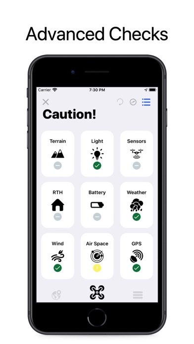
Drone Start is an advanced flight check & planning tool for drones. Drone Start is packed full of features that will help you plan a safe drone flight every time! You simply turn on your drone, plug your device into the drone controller, open the app & tap Start! Drone Start will then do a comprehensive set of checks to see if its safe to fly in your current area & it will even check your drones battery and sensors in real time to check your drone is in perfect condition to take off!
When your not out flying you can use Drone Start to create comprehensive flight plans, just type in where you want to fly and Drone Start will get Weather, GPS, Light Levels, Terrain Elevation, No Fly Zones and calculate the best time to fly that week! You can also plan your flight route and find out the elevation change & how much battery you'll have left! Plus loads more! You can view the area map and see No Fly Zones, Terrain Elevations, Sunrise/Sunset Times & Positions plus you can also see an animated Wind Map, showing the wind direction with colour coded arrows so you can immediately see if its too windy to fly or not.
Drone Starts calculation are also based on your drone model*, so things such as winds speeds and battery range are calculated using your actual drone!
Drone Start also has some great advanced features too such as:
Daily FlyCast
Daily FlyCast is a daily rich notification sent at sunrise every morning outlining the days flying conditions. You'll also have access to the FlyCast Widget, so you can always quickly check if its good to fly without even opening the app!
Solar Storm Warnings
Solar Storm Warnings are rich notifications informing you incoming solar storms which can cause high levels of magnetic interference which can affect GPS signals and impact the accuracy of your RTH point.
Intelligent RTH
If enabled Drone Start will automatically calculate and set your Return To Home Height based on surround terrain elevation, making sure your doesn't fly into a mountain side when it returns to you!
Fly Zone Alert
When enabled you will receive a notification informing you have entered a No Fly Zone, we will also let you know when you leave one too!
Battery Manager
Drone Start records battery data before each flight so you easily check battery health, including deviations. It also recommends battery rotation order if you have multiple batteries. You can also perform a battery test to check it's heath & efficiency, plus create pdf reports from the results.
Intelligent VPS
If there are large bodies of water in the area, Drone Start will automatically disable your VPS for you and automatically enable it next time you fly in an area with low amounts of water.
Broadcasts
Send Messages, Photos, Audio Messages, Flight Routes & Warnings to local drone pilots! Discover local obstacles and dangerous flying area when you fly in a new area!
Active Drone Alerts
Get notified when theres a another drone flying near your location.
Drone Start Features Include**:
Start Checks
- Weather, GPS, KP Index, Terrain Elevation & Airspace Checks
- Drone Law Checks
- Light Checks
- Drone Battery Health Check
- Drone Sensor Health Check
- ND Filter Check
- Wind Altitude Checks
- RTH Height Check
- Wind Map
- No Fly Zone Map
- Terrain Elevation Map
- Ephemeris
- Dedicated Drone Model Checks
- Golden Hour Times
- Water Area Check
- Active Drone Check
- RTH Reminder
Flight Plans
- 7 Day Weather Forecast
- 7 Day GPS Forecast
- 7 Day KP Index Forecast
- No Fly Zone Check
- Terrain Elevation Check
- Weather Check
- Wind Map
- No Fly Zone Map
- Terrain Elevation Map
- Ephemeris
- Best Time To Fly
- Flight Route Planner
- Dedicated Drone Model Checks
- Weekly Summary
- Drone Laws
- Light Check
- Aerial Images From The Area
- Golden Hour Times
*DJI Drone Models are only currently supported.
**Some Feature May Require An Active Monthly or Yearly Auto Renewing Subscription.
See our Terms of Use here: www.faulknerlabs.io/drone-start-terms
 このアプリはiPhone、iPadの両方に対応しています。
カテゴリー
ユーティリティ
ユーティリティ
リリース
2017/8/3
2017/8/3
更新
2017/11/9
2017/11/9
バージョン
1.6.4
1.6.4
言語
サイズ
199.3 MB
199.3 MB
条件
このバージョンの新機能
- Bug Fixes
- iPhone X Support
- Bug Fixes
- iPhone X Support
スクリーンショット - iPhone | iPad
スクリーンショット - iPhone | iPad
Neil Faulkner の他のアプリ » もっと見る
» 目的別iPhoneアプリ検索
- 辞書 » 日本語対応の辞書 » 英和辞典
- 学習 » 英単語 » 英会話 » クイズで楽しく
- スケジュール » 管理 » Googleカレンダー


Simeji - 日本語文字入力&きせかえ・顔文字キーボード
Baidu Japan Inc.無料
Google アプリ
Google LLC無料
Chrome - Google のウェブブラウザ
Google LLC無料
Clipbox
VIGROS, LIMITED LIABILITY CO.無料
My au
KDDI CORPORATION無料
flick(フリック)- みんなの顔文字キーボードから名前が..
IO Inc.無料
SmartSearch from Yahoo!検索
Yahoo Japan Corp.無料
ヤマダ電機 ケイタイde安心
BIPROGY Inc.無料
通信量チェッカー
InnoX Co.,Ltd.無料
無料QRこーど りーだー:QRコード&バーコード リーダー読..
MixerBox Inc.無料


CatchApp新着アプリレビュー
 日本縦断てつどうの旅」")
様々な楽しみ方で運転士として成長していく鉄道運転士育成RPG「プラチナ・トレイン(プラトレ) 日本縦断てつどうの旅」
2016-05-17 00:00

日本語にはない英語発音のリスニングを楽しく学べる「発音どっち?英語リスニング 」
2014-12-20 12:00

指先の瞬発力が試されるカジュアルゲーム「早撃ちパニック」をリリース!
2014-12-08 15:21
新着アプリ動画
-
 ¥1500
¥1500
-
 ¥600
¥600
-
 ¥3000
¥3000