


このアプリのYoutube動画がある場合はURLを送信してください。詳細 »
APPLICATION INFO - iPhoneアプリの詳細情報

-

- Share on Tumblr
- Check
- ツイート
Topoguide app gives access to all our hiking destinations in Greece.
You can see a list of the destinations here: http://www.topoguide.gr/index-en.php
The free version of the app contains the routes of the the "O" national paths of Greece, and gives access to a demo destination: Lycabettus in Attica region.
The other destinations are sold as in-app products, and each give access to:
• Dozens of hiking and cyclings routes with descriptions and photos
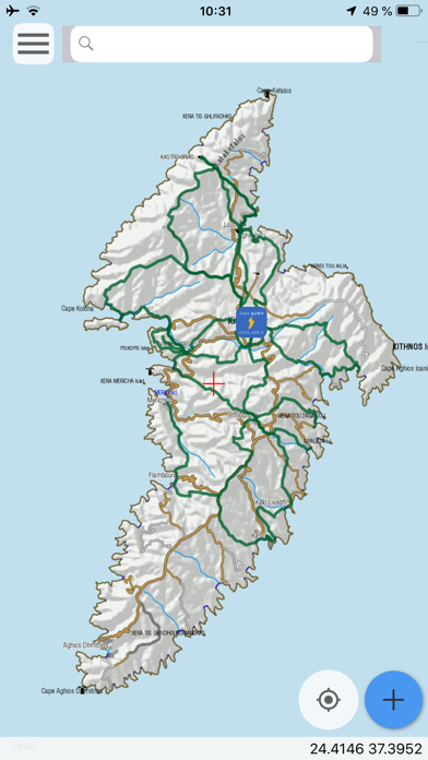
• Offline topographic maps of the area
• Guidebook with an extensive introduction on the geography, the nature and the paths of the area
• Offline search for hundreds of POIs
In the field, the app identifies the nearest adventure, guides you to it and then along it by displaying messages and warnings on every junction or other important location. On each Point of Interest, photos and texts are displayed on the map. If the hiker gets off-trail, the app indicates the shorter way to get back safely.
Also, a navigation feature allows to calculate routes and distances along roads and paths anywhere on the island.
The cartographic company Topoguide, creator of the application, has issued previously hundreds of detailed printed hiking maps for Greece. To ensure data accuracy, all paths are walked by our team of specialists.
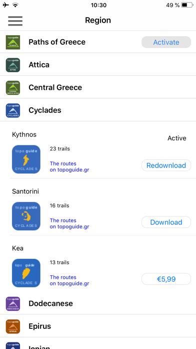
The available in-app products for each region are:
• Attica: Athens birding, Geraneia, Hymettus, Kitheronas, Lycabettus, Parnitha, Pendeli
• Central Greece & Evia: Dirfys, Elikonas, Giona, Nafpaktia Uplands, Oeta, Parnassos, Vardousia
• Peloponnese: Chelmos, Elafonisos, Mani - Avia, Mani - Kardamili, Menalon Trail, Methana, Parnonas, Taygetos, Ziria
• Thessaly: Central Pelion, East Pelion, South Pelion, West Pelion
• Macedonia: Valia Calda
• Epirus: Ursa Trail, Zagori
• Crete: Chania, Gramvousa, Lefka Ori
• Cyclades islands: Amorgos, Kea, Kythnos, Naxos, Santorini, Sifnos, Tinos
• Ionian islands: Corfu Trail, Kefalonia, Zakynthos
• Saronic islands: Aegina, Hydra
• Sporades islands: Skyros
• Dodecanese islands: Kalymnos
DISCLAIMER
During track recording, continued use of GPS can dramatically decrease battery life.
You can see a list of the destinations here: http://www.topoguide.gr/index-en.php
The free version of the app contains the routes of the the "O" national paths of Greece, and gives access to a demo destination: Lycabettus in Attica region.
The other destinations are sold as in-app products, and each give access to:
• Dozens of hiking and cyclings routes with descriptions and photos
• Offline topographic maps of the area
• Guidebook with an extensive introduction on the geography, the nature and the paths of the area
• Offline search for hundreds of POIs
In the field, the app identifies the nearest adventure, guides you to it and then along it by displaying messages and warnings on every junction or other important location. On each Point of Interest, photos and texts are displayed on the map. If the hiker gets off-trail, the app indicates the shorter way to get back safely.
Also, a navigation feature allows to calculate routes and distances along roads and paths anywhere on the island.
The cartographic company Topoguide, creator of the application, has issued previously hundreds of detailed printed hiking maps for Greece. To ensure data accuracy, all paths are walked by our team of specialists.
The available in-app products for each region are:
• Attica: Athens birding, Geraneia, Hymettus, Kitheronas, Lycabettus, Parnitha, Pendeli
• Central Greece & Evia: Dirfys, Elikonas, Giona, Nafpaktia Uplands, Oeta, Parnassos, Vardousia
• Peloponnese: Chelmos, Elafonisos, Mani - Avia, Mani - Kardamili, Menalon Trail, Methana, Parnonas, Taygetos, Ziria
• Thessaly: Central Pelion, East Pelion, South Pelion, West Pelion
• Macedonia: Valia Calda
• Epirus: Ursa Trail, Zagori
• Crete: Chania, Gramvousa, Lefka Ori
• Cyclades islands: Amorgos, Kea, Kythnos, Naxos, Santorini, Sifnos, Tinos
• Ionian islands: Corfu Trail, Kefalonia, Zakynthos
• Saronic islands: Aegina, Hydra
• Sporades islands: Skyros
• Dodecanese islands: Kalymnos
DISCLAIMER
During track recording, continued use of GPS can dramatically decrease battery life.
 このアプリはiPhone、iPadの両方に対応しています。
カテゴリー
旅行
旅行
リリース
2019/3/27
2019/3/27
更新
2019/11/6
2019/11/6
バージョン
1.1
1.1
言語
サイズ
33.8 MB
33.8 MB
条件
このバージョンの新機能
• Route preview on the map
• Export user data in GPX or KLM
• Restore purchases button to restore purchased areas after a new installation
• Route preview on the map
• Export user data in GPX or KLM
• Restore purchases button to restore purchased areas after a new installation
スクリーンショット - iPhone | iPad
スクリーンショット - iPhone | iPad
Topoguide - T ADAMAKOPOULOS - A ADAMAKOPOULOS O.E. の他のアプリ » もっと見る
» 目的別iPhoneアプリ検索
- 辞書 » 日本語対応の辞書 » 英和辞典
- 学習 » 英単語 » 英会話 » クイズで楽しく
- スケジュール » 管理 » Googleカレンダー


Google Earth
Google LLC無料
じゃらん
Recruit Co.,Ltd.無料
楽天トラベル
Rakuten Travel Inc.無料
ホテルズドットコム - 国内・海外のホテルをお得に予約
Hotels.com無料
ANA
ANA (All Nippon Airways)無料
アトラクション待ち時間
NORIHIKO HAYASAKA無料
エクスペディア - ホテル予約、格安航空券&現地ツアー予約
Expedia, Inc.無料
まっぷるリンク
Shobunsha Publications, Inc.無料
週刊じゃらん -旬の観光・グルメ・宿情報をまとめ読み
Recruit Co.,Ltd.無料
ホテル予約 厳選20社 旅比較ねっと
BIGLOBE Inc.無料


CatchApp新着アプリレビュー
 日本縦断てつどうの旅」")
様々な楽しみ方で運転士として成長していく鉄道運転士育成RPG「プラチナ・トレイン(プラトレ) 日本縦断てつどうの旅」
2016-05-17 00:00

日本語にはない英語発音のリスニングを楽しく学べる「発音どっち?英語リスニング 」
2014-12-20 12:00

指先の瞬発力が試されるカジュアルゲーム「早撃ちパニック」をリリース!
2014-12-08 15:21
新着アプリ動画
-
 ¥1500
¥1500
-
 ¥600
¥600
-
 ¥3000
¥3000